In the last post we looked at how the historic maps of the Ordnance Survey can be used to see what your house, village or town looked like in times past. However, these only take you back to the early 1800’s, and then not in great detail, or the 1870’s, if you want to be able to pick out an individual house. But there are maps that will take you back further, and in some cases a lot further.
The first port of call on our journey back in time are the Tithe maps, produced in the mid-19th century in order to facilitate the calculation of the new monetary tithes that landowners were required to pay, as opposed to the old payments in kind (agricultural produce). These maps cover the majority of the country by parish and are at a much more detailed scale than the one inch Ordnance Survey. Back in the day when they were made, three copies were produced of each map, one went to what was essentially central government (now held in the National Archives), one to the Diocese and one to the parish. It is these latter that are now the most easily accessible, since the majority ended up in Local Authority Record Offices. For South Harting the local Record Office is that for West Sussex in Chichester, and the Tithe map can either be viewed there, or purchased from them on CD. At some stage it is to be hoped that they will appear online.
For some places the Ordnance Survey maps and the Tithe are going to be your only historic maps, but for others a whole new world of mapping can open up, from enclosure maps (as the name suggests drawn up to map the enclosure of common land) to private estate maps and other more random examples. These can be held anywhere, including in private collections, but the most accessible ones are held in public archives, such as the National Archives, the British Library or local record offices. All of these have searchable catalogues of what they hold, so it is fairly easy to find out what maps they might have for your area.
In the case of Harting there are more the ten maps pre-dating the Tithe, but the best of all is one held by the British Library (No. Add MS 20089 A). As you might imagine, the further back in time you go, the fewer maps there are, with only a comparatively small number pre-dating the 18th century. But the British Library’s Harting map is one of these, and dates back nearly 400 years, to 1632.
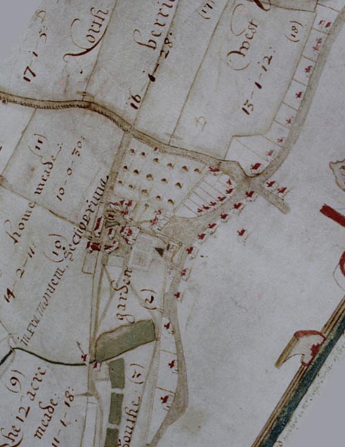
(British Library No. Add MS 20089 A)
Often these older maps are very colourful and tend to include all sorts of extra decoration and details. They also commonly show the buildings in a sort of 3D, rather than from a bird’s eye view, as modern maps do. The titles that go with them are also often rather long and elaborate, as it is with this map, which reads: “An exact & perfect description & general plan of the manor of West Harting in the county of Sussex wherein are set forth & delivered all the houses, gardens, tenements, cottages, woods & underwoods, wastes, commons, warrens, sheep downs & lands situated, lying & being within the tithing of West Harting belonging to Sir John Carill knight now lord of the same manor” and then it carries on quite a bit longer.
Sadly of all the maps discussed above, and in my previous post, only the Ordnance Survey ones are available to view online, which is not terribly helpful in the present circumstances, when we just cannot get to record offices and other archives. It is to be hoped that some day all these old maps will be scanned and make their way onto the web for all to see.